No, we didn’t see any Kiwi birds, but we did have a fortuitous encounter with a friendly bunch of Aucklanders at the start of the Comans Track in Waitkatere Ranges National Park. (Note about the park and Kauri Dieback disease at the bottom of this post)
After arriving in the tiny beach town of Piha, our final stop in our three-week North Island stay, we planned our first hike to be the Comans/Mercer Bay Loop Track which starts at Karekare, a 20 minute drive from our AirBnB rental in Piha.
Arriving at the trailhead we found a large group of hikers gathering in the parking lot, (who turned out to be the Auckland Hiking Group on Meetup.com) so we asked if we could join them. Being friendly Kiwis, or course the hike leader said yes! Just like when we lead day hikes for the Sierra Club in California, before setting out the leader had everyone form a circle and introduce themselves. We were surprised to learn that over half of the approximately 30 people were not New Zealand born, although they were all living in the Auckland area. Country names I heard included China, Russia, Poland, Iran, Switzerland, Zambia, and an American from Cupertino, a few miles from where we live.
Russell mentioned at the start that there would be a water crossing. Okay, we are used to stream crossings. Except it turned out to be more like a river crossing (photos courtesy of Lauren Fuhri).
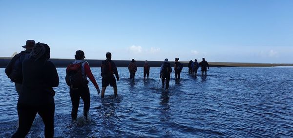
 I paused on the shore and watched people go across without taking their boots off, in water up to their knees. I will go to great lengths to avoid hiking in wet socks and boots, so I took everything off my feet and waded through. But only two other people did that; everyone else just plunged in and spent the day with squishy feet.
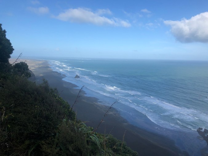
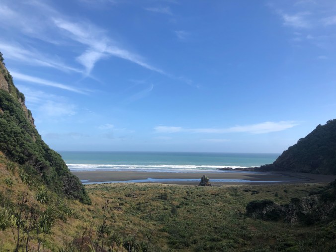
Once we got on the Comans Track it was not difficult, very well maintained with a nice gravel surface and lots of newly constructed steps for the steep parts. We quickly gained over 180m and enjoyed the view of Karekare Beach to the south.
Hike leader Russell had warned us at the start that part of the hike was a “steep section with four fixed ropes” and when we got to that point we decided it was a too extreme for our taste — it looked like an almost sheer cliff — so we thanked him and continued back to the trailhead. The next day I found the specific Meetup page about the hike and was even happier that we had decided not to continue based on these images posted after the hike (photos below again courtesy of Lauren Fuhri: we did not attempt this drop off!).


On the way back we had more great views of the coast, and enjoyed our lunch spot above the beach.


On the track I spotted a native New Zealand plant, Corokia cotoneaster, which we planted in our yard over 15 years ago. Ours is not doing as well as the plants in these photos, perhaps because it does not get enough water in the summer.


We also saw this rather bizarre fungus (note the tip of Rosemarys hiking pole on the left, for scale).

The weather was fine and we were happy to get the opportunity to meet some fellow hikers in New Zealand!

Next > Piha Beach Walking: Wind, Sand, and Surf
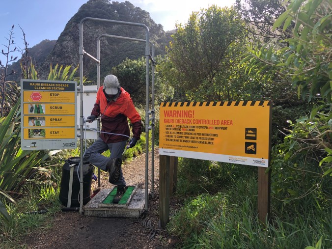
Note about Waikatere Ranges Tracks and Kauri Dieback Disease
Kauri Dieback disease is killing kauri trees in the Waitakere Ranges Regional Park and in some other forests on the North Island. The closure of some Waitakere tracks and the creation of protection zones helps prevent the spread of this disease, but anyone using the park can play their part to save kauri. Track users are asked to observe these guidelines when visiting:
- Always make sure your shoes, tyres and equipment are cleaned to remove all visible soil and plant material before and after visiting kauri forest.
- Always use the cleaning stations installed on major tracks.
- Stay on the track and off kauri roots.
- Keep your dog on a leash at all times or leave them at home.
Find out more about Kauri Dieback and the track closures here. This map shows the currently open tracks in the park.
The closures are strongly objected to by some of the local residents who claim that the research supporting the closures is flawed and that the Auckland Council is simply closing trails indefinitely without a plan. Scientists disagree, saying humans are the primary reason Kauri Dieback is spreading (other animals like wild pigs are also a vector, and hunting contracts have been awarded to try to reduce their numbers). The Council says there is a plan and funding to upgrade the closed tracks over the next decade so they are not muddy (the fungus pathogen causing the disease can spread through water moving through the soil) and it appears the vast majority of New Zealanders support the track closures.
I think the people objecting to the track closures aren’t looking at the big picture, and expect too much, too soon. Speaking as a biologist, I would tell them that if more Kauri trees die that can radically alter the forest they love because other plant species depend on the Kauri to thrive, as they are a foundation species. Yes, in the 19th century many New Zealand forests were heavily logged and stripped of most of their vegetation, which then grew back. But Kauri trees take centuries to reach maturity. We have to think long term and give the forest a chance to recover, and we need data collected over years to make intelligent decisions. Short term thinking, believing that closing trails for months or a few years will solve the problem, is not the solution. I may be criticized as an “outsider” for taking that position, but science and rational analysis isn’t limited by national boundaries; it applies everywhere.
Here I am at the boot cleaning station at the entrance to Comans Track. When I planned our trip to New Zealand last year I first read about the Hillary Track in the Waitakere Ranges National Park and got excited thinking about hiking it. Then I learned that most of the tracks in the National Park were closed due to Kauri Dieback. I adjusted my expectations and during our time in Piha am enjoying the tracks that remain open.

Pingback: Great Lake Trail: the W2K Track to the Headlands | Electric Travels