We were descending the Clear Creek Trail at 8,000 ft, near the tree line, on the south slope of Mt Shasta. I watched the shadow of a large bird trace across an open area devoid of trees and looked up to see a bald eagle soar upslope. It was a warm, clear day and the view of the peak was spectacular. Rosemary was six feet ahead of me and suddenly stopped, looking to her right. I paused and followed her gaze, glimpsing dog-sized hindquarters attached to a long bushy red tail just before it disappeared into a thicket of low manzanita.
“Did you see the entire animal?” I enquired, mentally eliminating various possibilities of medium-sized mammals; coyote, bobcat, giant squirrel (okay, I made up that last one).
”I think it was a fox, and it had a small black rodent in its mouth!”
Later, back at the campground, we went online and confirmed that it must have been the rare Sierra Nevada Red Fox. We used the CDFW online form to report our sighting.
We camped for eight days at the McCloud RV Resort, surrounded by big rigs. Our 17 ft Alto F1743 trailer appeared comically small between an enormous 5th wheel rig and a giant Class A motor home. Fortunately, we could create an illusion of privacy by placing our table and chairs at the back of our site and enjoy a view of the mountain.


It was mid-July and the daily highs for the small town of McCloud, situated at 3,200 ft, were in the 90’s. Fortunately our campsite was well shaded in the afternoon. This was our first hiking trip to the Mt Shasta area, and we hiked for seven straight days. We quickly realized that even though there were many fine hikes at less than 5,000 ft, it was better to stay high where the temperatures were more moderate.
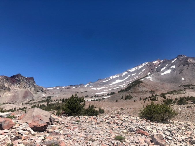
There are many websites with information about hiking trails. We relied on the Hike Mt Shasta site and found it very useful. The easiest way to stay high on the mountain is to take the paved road that goes the highest, the A10 road called the Everett Memorial Highway that goes from downtown Mt Shasta up to 7,800 ft, ending at the Old Ski Bowl trailhead (a now defunct skiing operation that opened in 1958 and closed in 1978 when the main chairlift was destroyed by a massive avalanche). Below is a view of the Old Ski Bowl area from Hummingbird Saddle near the start of the trail to South Gate Meadows. Green Butte is at the left and Sargents Ridge is at the far right, blocking a view of the summit of Mt Shasta from that vantage point.
From the A10 trailheads at Bunny Flat, Panther Meadows, and the Old Ski Bowl you can access many great hiking trails, and we did most of them! On summer weekends it’s best to arrive early in the morning to secure a parking space, but during the week we had no trouble parking.
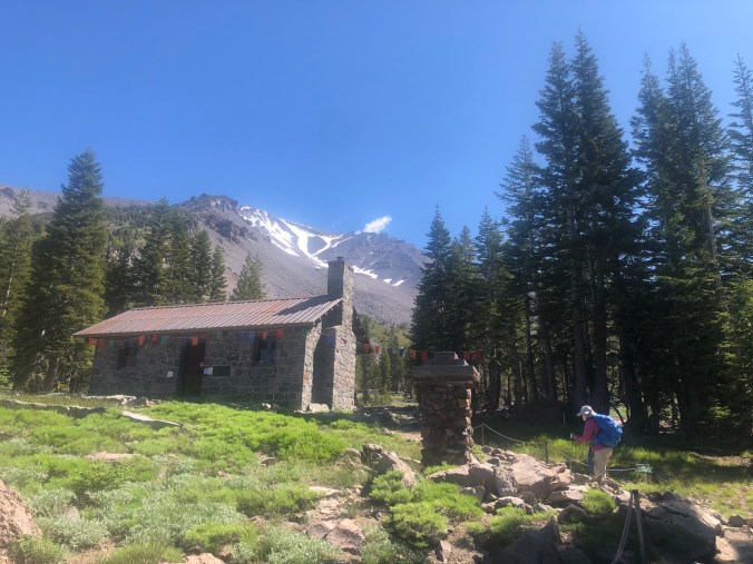
From Bunny Flat, the Horse Camp Trail is a popular trail, primarily because it is the beginning of the most heavily used route to the summit, the Avalanche Gulch Trail, but also because it leads to the historically interesting and picturesque Shasta Alpine Lodge at 7,884 Ft on land owned by the Sierra Club Foundation.
At that point you can either stay on the Horse Camp Trail on up to tiny Helen Lake at 10,443 ft, a tough climb with lots of scree and talus slopes, or head north on the Hidden Valley Trail, not as difficult but still challenging with some steep sections and a large boulder field near the end which requires great care in traversing. Another option from the Alpine Lodge is to head east where a very steep trail leads up to Green Butte, offering incredible views. None of those trails are “engineered” in the sense that switchbacks provide relief during the uphill sections; often they are really just scrambles up loose rocky soil, so be careful and always save energy for going down!
Mid-July at those elevations is springtime and the more we looked the more wildflowers we spotted.


A particularly interesting plant had the most remarkable looking seed pods I have ever seen.


At that time of year, butterflies are plentiful. The most common was what I think is called the Silver Washed Fritillary. We saw them everywhere, including in small clusters on scat on the trail (photo below right). Apparently they can extract nutrients from dung! Impressive.


Next > a stunning hike in South Gate Meadows provided a wonderful ending to our trip.


If you are still up at Shasta, head over to the Trinity Alps Wilderness. I hiked Canyon Creek Lakes last week. It is in the trees until you reach a couple of beautiful alpine lakes.
LikeLike
We got home several days ago. Plan on going back to the area of course; lots of hikes left to do!
LikeLike
Wow. Gorgeous pics and a stellar setting. Did you notice the lack of O2 up at that height?
LikeLike
We live near sea level, so going uphill at 8,000 ft is noticeably more difficult. But many people much fitter than I aren’t bothered by it.
LikeLike